Insight
Canoeing is a way to sit still and pay attention.
|
Insight
|
Canoe TripsBoundary Waters:
Boats & GearBoundary Waters Gear ListWenonah Prism (sold)
|
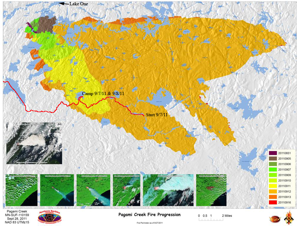
BWCA - September 6-20, 2011Page 8: The Pagami Creek FireThis map shows the extent of the fire on a near-daily basis from August 31 to September 16. I've marked it up to show my route through the burned area and the location of the Lake One Entry Point. This image is from the Inciweb site, which indicates a total burned area of 92, 682 acres (145 square miles). The greatest number of personnel on duty at any one time was about 850, and as of Oct. 22, 2011 the cost to contain the fire was $22.3 million.
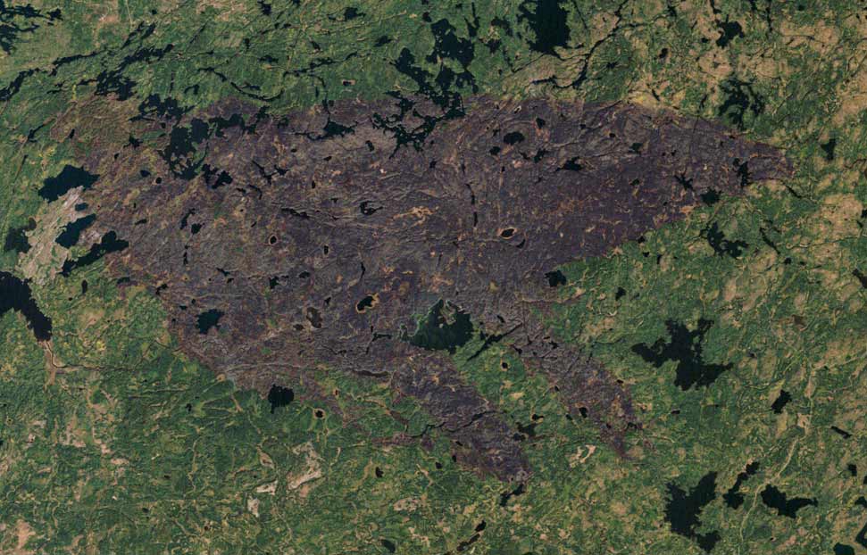
This image, from NASA, shows the fire's burn scar on October 11.
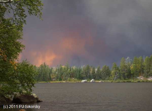
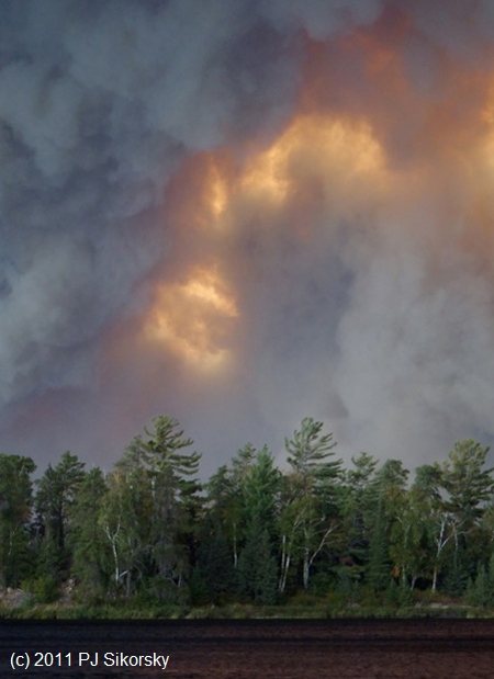
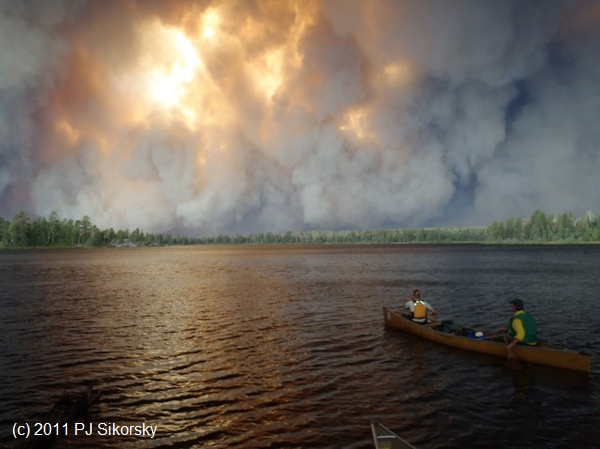
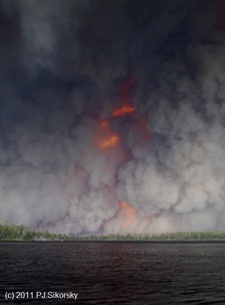
Many thanks to PJ Sikorsky for sharing the following photos which were taken from the landing at Kawishiwi Lake [EP37] on September 12, 2011. They are used here with permission. PJ also shared some trip notes with me: "Just a couple notes about our trip. We were originally planning on entering the BWCAW at Lake One, but the entry point was closed due to the fire, and the Forest Service suggested Kawishiwi Lake as a safe alternative. We put in (there were nine of us in four canoes) at about 11:30 AM under blue skies with a slight breeze out of the NW. The smoke cloud was barely visible on the far northwestern horizon. We paddled from Kawishiwi Lake up a small creek into Square Lake, and while we were paddling the wind was building continuously. By the time we got to Square Lake there were white caps on the lake, which was pretty amazing because it is a very small lake. Shortly after entering Square Lake one of the canoes in our group was blown onto some rocks and capsized. Fortunately, the water was shallow and the day was still warm so we were able to get everybody out of the water and dried off. "While were waiting on shore we could see the smoke cloud getting closer. We made the decision to return to Kawishiwi Lake rather than proceed on the route we had planned. It continued to get darker and darker as we returned to Kawishiwi. Ash started to fall, the air got very smoky, there were periods of eerie calm, and then huge gust of winds as we were paddling back through the small creek. When we got to Kawishiwi Lake a Forest Service plane buzzed us, which we took to mean that we should return to the landing. When we arrived there were the Forest Service and MDNR officers shown in one of the photos telling us the area were in was closed and they were going in to see if they could find others to escort out. We had seen some campers on Square Lake and talked with them; they were planning on staying put, and I presume they changed their minds and left. The [following] photos were taken at about 3:30 PM from the landing at Kawishiwi Lake. "According to the September 13 Duluth News, a couple on Kawasachong Lake had to seek refuge in the water as the fire burned over their campsite at 4:00 PM. We were planning on portaging into Kawasachong from Square Lake before the one canoe capsized. Had it not been for that we may have been on the portage when the fire went through - not a pleasant thought." - PJ Sikorsky
Here a US Forest Service Officer and MN DNR Officer enter Lake Kawashiwi to help paddlers exit:
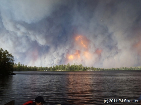
I estimate the trees at the bottom left of this picture at about 100 feet tall. That would make the flames at least 1,500 feet high - over one-quarter mile.
|
Comments and suggestions welcome. Feel free to e-mail
me.
Last updated
December 27, 2011
Brought to you by Codabone Productions ©2009